Tibetpedia

Category: Lakes

Lakes of Tibet

Tibet holds a stunning array of natural scenery, and its lakes are no exception. Due to the elevation of the Tibetan plateau, the water in these lakes is often a jaw-dropping sight as the lake clearly reflects the sky. This means as the skies change, so does the colour. All over Tibet the lakes appear as emerald jewels, big and small, dotted across the landscape and tucked away in mountain ranges.

To view the lakes by region, along with other attractions nearby, visit:

To view a map of Tibet and an introduction to the three main Tibetan regions, visit our page on Tibet Travel Essentials.


  • Mtsho khra khrap (Flower Lake)

    Mtsho khra khrap (Flower Lake)

    Officially known as Ruoergai Wetland National Nature Reserve, this area is commonly known in Chinese as Hua Hu which literally translates: Mtsho khra khrap (མཚོ་ཁྲ་ཁྲབ།) In Tibetan. We call it Flower Lake in English. The name comes from the flower shape of the lake, not because it holds an abundance of blooming flowers (a common misconception). Regardless, walking the boardwalk around the marsh leading to the lake itself, travellers are taken with the beauty that is Flower Lake.

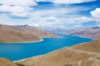
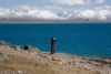
    Located at an altitude of 3,600 meters above sea level, Flower Lake is the largest plateau marshland in the world, and was officially recognized in 1988 as a national nature reserve. Watching the sky reflect off of the lake in contrast to the colour of the reeds, is part of what makes Flower Lake so popular to visit.

    The road to flower lake
    The road to flower lake

    The Wildlife

    When visiting Flower Lake, keep your eyes open for the wildlife. This marshland is home to several endangered species, and it was recognized in 2005 as the homeland of the Black-Necked Crane. Bird watchers may also spot the red-crowned crane, white crane, swans, and yellow ducks. Other animals within the park include the lake’s fish, and the livestock belonging to the nomads.

    Getting There

    Flower lake is located approximately halfway between Ruoergai County Town and Langmu Monastery, making this a convenient stop for travellers. When heading north out of Ruoergai, it is approximately a half hour drive with visitors choosing to take the bus, taxi, or private vehicle to get there.

    A sawn in the flower lake
    A sawn in the flower lake

    Visiting Flower Lake

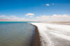
    Once at the entrance to the nature reserve, the entrance price is ¥101 during peak season (May – mid October), while it is only ¥30 the rest of the year. Even though it is more expensive, the recommended time to visit Flower Lake is June-October, as the winter months see the marshes covered in snow. In the summer months the marsh reeds are a luscious green, while in the fall the reeds turn golden yellow with the colder weather.

    Once inside the park you will load onto a bus (paid for with your entrance ticket), and drive about 10 minutes until you reach the boardwalk stretching out over the marshland. The boardwalk is fairly wide and well maintained making this site easy to visit. However, the majority of the boardwalk has no railing over the deep marsh water, so parents will want to watch their small children. For travellers with mobility issues, barring the elevated observation platforms, there are only a couple of small steps scattered throughout the boardwalk.

    Inside Flower lake
    Flower lake is a nice place to experience the beauty of nature

    Flower Lake Nature Reserve is open for guests from 6:30am-7:00pm year round. Go early in the morning to avoid the crowds, as this is a popular scenic spot for national tourists. By visiting in the morning, you will also avoid the heat of the afternoon sun (although you should still be prepared for the weather).


  • Erdaohai Lake

    Erdaohai Lake

    Located just outside of Songpan in the Mounigou Gulley Scenic Area is the breathtaking Erdaohai Lake. While this is not the only lake or scenic spot located in the park, it is one of the two most famous places in the Mounigou Gulley, ensuring the park is known by this name (The other park in Mounigou Gulley is Zhaga Waterfall.)

    Known for its stunning colour, this lake is set at an altitude of 3,385 meters above sea level and covers an area of approximately 16,027 square meters. With karst caves located underneath, the plateau sink-lake is fed by the surging undercurrent. At its deepest point the lake is approximately 28 meters deep, and it is this changing depth of the mountain water that gives the lake its vibrant and shifting colours. Located at such a high elevation, the lake not only reflects the forest around its edges, but the living sky above.

    One of the beautiful lakes in Erdaohai
    One of the beautiful lakes in Erdaohai

    Other Attractions Within the Park

    In Erdaohai Park, there are actually a number of different lakes/pools that guests like to visit. Each of the lakes or pools is a different colour, and the sparkling clear mountain water displays the interesting elements of each place. This includes: Lovers Emerald Pool, Jade Lake, Toudaohai Lake, Swan Lake, Singing Spring, the Travertine Annual Rings, Jade-Dropping Pool, Grass Lake, and Hot Spring Lake.

    Besides these, one of the lakes is known for the algae that grows in it that looks like the branches of a pine tree, while at another point in the park there is an actual pine tree that seems to grow straight out of a rock face. Also, worth spotting amongst the trees is the Karast Cave Group, with several of the caves extending deep into the earth. No matter where you look the park is beautiful with the forest, wildflowers, occasional animal, and the wide open sky.

    Inside Erdaohai Lake
    Inside Erdaohai Lake

    Getting There

    When going to Erdaohai Lake, your best option is to take a taxi or private vehicle out of the town. We took a taxi, and for the price quoted us, he was willing to wait for us for the three hours we wanted to spend in the park. At the time of writing, the entrance ticket to Erdaohai Lake cost ¥70, but to see the stunning colour of each of the lakes is well worth it.

    Inside Erdaohai Lake

    Once inside Erdaohai Lake, the walk will take approximately 2-3 hours depending on the speed at which you want to walk and the amount of times you stop to take in the view. The lakes themselves are set further back into the park with the first appearing after about 15 minutes of walking.

    A smooth wooden boardwalk leads visitors through the park making it a nice walk, however, for those with mobility issues, there are a number of steps in the park. Essentially the park tours a mountain side, so the height of the terrain changes as you go further in, but the boardwalk takes it from being a hike to a walk. When walking in the park, you will come to a couple of forks in the road, however, the entire park is set up as a loop, so by taking one road over the other, you aren’t actually missing anything.

    Beautiful view inside Erdaohai lake
    Beautiful view from inside Erdaohai lake

    If you walk right to the back of the park, guests are rewarded with a hot spring in which you may choose to dip your feet for a few minutes. However, don’t be surprised: the hot spring might not be as “hot” as you expect. The spring deserves this title because it never dips below 10°C in a year, which at the elevation is significant enough to differentiate it from the surrounding lakes. (To the amusement of those who sat at the pool longer, we saw more than one guest startle at their initial test of the water.)

    When visiting the park, dress for the weather, and make sure you bring a water bottle. There are gazebos and benches scattered throughout the park if you want to enjoy a picnic lunch, but to do so will require you to bring the food with you from town as there is no place to buy it there.

    Prayer flags in Erdaohai Lake
    Prayer flags in Erdaohai Lake

  • Lianbaoyeze Holy Mountain

    Lianbaoyeze Holy Mountain

    Driving about an hour and a half north of Aba town, travellers are rewarded with the spectacular views to be found at the Lianbaoyeze Holy Mountain (གཉན་པོ་གཡུ་རྩེ།) Scenic Area. With a mountain range surrounding a large lake, the air here feels clear and pure. The area surrounding the Lianbaoyeze Mountain is a scenic park, meaning there are a couple of things to see and do.

    Lianbaoyeze Holy Mountain

    The mountain itself is considered holy due to its Tibetan folklore history. The holy mountain is described as having a front gate, and doors on four sides. Each door and side of the gate has a different god associated with it making this mountain the home of six divinities. It is said that to the left of the gate is “Layagawu” (a white divine cattle), with the right being “Jiashidamawu” (a red divine tiger). Meanwhile, the gods of the doors are “Pawengzhiyu” in the north (a cubic magic stone), “Kecainangqian” in the south (an elephant), “Lawengtuoga” to the east (a white-forehead mountain divinity), and “Zhayisecha” to the west (a gold-armored mountain deity).

    It also seems that wherever you go in Tibet the epic of King Gesar has a local legend. The Lianbaoyeze area is no different, as the stories say that the area was King Gesar’s battlefield.

    A stupa in Lianbaoyeze Holy Mountain
    A stupa in Lianbaoyeze Holy Mountain

    Zhagaercuo Lake

    According to the local who took us, there are approximately 360 lakes on this mountain, with Zhagaercuo being just one of them. This lake lies at an elevation of 4,200 meters, and the beautiful clear water occupies 3 square kilometers. Zhagaercuo Lake is hidden from the road when you approach, but after an approximately 20-minute walk on the recently built boardwalk, this stunning highland lake comes into view. (Note: This includes several flights of stairs, and due to the elevation, it may take you longer as you catch your breath).

    A Lake in Lianbaoyeze Holy Mountain
    Zhagarecuo Lake in Lianbaoyeze Holy Mountain

    Other Activities

    There is space within the grounds of the park to camp alongside the river, or there are a few guest houses at the base of the mountain. If you wish to hike or walk, there is a trail that runs alongside the river from the park entrance to the base of the mountain (at which point it turns into the previously mentioned boardwalk). There are also new roads being built in this park, meaning that new scenic locations are becoming accessible to visitors all the time.

    Getting There

    The drive to Lianbaoyeze Holy Mountain Scenic Area takes about an hour and a half from the town of Aba. As there are no buses running to this area, your best option is a private vehicle hire. While this may seem a bit out of the way, the trip is well worth it.

  • Yamdrok Yumtso (Yamdrok Lake)

    Yamdrok Yumtso (Yamdrok Lake)

    Yamdrok, Yamdroktso (ཡར་འབྲོག་གཡུ་མཚོ།  ), or Yamdrok Yumtso, is a breathtaking lake lying between the Tibetan capital, Lhasa, and the town of Gyantse. Yamdrok Lake is viewable along the old Friendship Highway that links Tibet with Nepal, and is a favorite route for those heading to Everest Base Camp. Sitting at an altitude of 4,441 meters above sea level, the lake is 130 kilometers in length and 70 kilometers in wide at its furthest spot. Yamdrok is the largest inland and freshwater lake on the northern Himalayan range with an average depth of 20 to 40 meters, and the deepest point being 60 meters.
    Yamdrok Lake Tibet
    Summer time views of the lake offer green carpeted slopes on the surrounding hills.

    Yamdrok Lake has a unique coral shape with numerous streams feeding it from nearby mountains, hence the locals refer to it as Coral Lake. It is also sometimes called Green Jade Lake for its smooth surface similar to the fine jade, and its gorgeous color hues from the reflection of sunlight.

    Religious Significance of Yamdrok Lake

    Yamdrok Lake is one of the four largest sacred lakes of Tibet along with Lake Lhamo Latso, Lake Manasarovar, and Lake Namtso. According to Tibetans, the lake is considered as the life line of the inhabitants. It is said if the lake dries up, Tibet would become an inhabitable place. The lake is considered to be guarded by the goddess Dorje Gegkyi Tso. Tibetans perform pilgrimage to Yamdrok Lake and circumambulate around the lake in seven days to wash away their sins and earn merit. The lake’s spiritual energies are associated with the Second Buddha, Padmasambhava, who brought Buddhism to Tibet. Moreover, Buddhists believe Lake Yamdrok helps them find the reincarnated soul of the Dalai Lama. There is also the famous Samding Monastery headed by a female reincarnation on a peninsula near the lake.

    Rolling hills by Yamdrok Lake
    Yamdrok Lake with snow capped mountains in the backround

    Natural Habitat in and around Yamdrok Lake

    The crystal clear, freshwaters of the Yamdrok Lake and its surroundings are home to fish, migratory birds and flocks of sheep. Yamdrok Yumtso Lake has shoals of freshwater fish named Gymnocypris przewalskii, which swim to the shallow water to lay eggs every summer. The lake is the largest habitat for migratory birds in southern Tibet as well. During the season, the lake bank and its islands are dotted with numerous birds and their offspring. There are no wild animals in the region but local Tibetans can be seen grazing herds of goats, sheep and yaks on the rich summer pastures.

  • Tsongon Po (Qinghai Lake)

    Tsongon Po (Qinghai Lake)

    Known as Qinghai Lake in Chinese (meaning Green Lake), Kokonor in Mongolian (meaning Blue Lake) and Tsongon Po (མཚོ་སྔོན་པོ།) in Tibetan (meaning Teal Sea), this largest inland saltwater lake in China is found in the Qinghai Province. Amidst the lofty mountains of Xiangpi, Datong, Riyue, and the South Mountain, Qinghai Lake is spread over an area of 4,500 square kilometers at an elevation of 3,200 meters. The natives believe Qinghai Lake is a miracle bestowed by a deity.

    The vast grasslands surrounding Qinghai Lake are dotted with flocks of sheep and goats, shepherds’ tents, golden rape seed flowers, and wheat fields. The Qinghai Lake is dotted with five unique-shaped islands including the Haixin Hill, Gucha Hill, Bird Island, Haixi Hill, and Sand Island.

    Bird Island (Niaodao)

    To the west of the Qinghai Lake is the Niaodao, which is the ‘Kingdom of Birds’. Bird Island covers an area of 0.11 square kilometers and reaches ten meters above the lake. The island is a natural habitat for more than 100,000 birds of diverse species such as swan, gull, sandpipers, wild goose, crane, and even the rare black-necked crane. During the spring and summer months, thousands of birds from as far as Southeast Asia flock to their kingdom to breed.

    Haixin Hill (Hill of the Sea Heart)

    25 kilometers from the Bird Island is Haixin Hill, also known as ‘Immortal Hill’. It lies to the south of the central Qinghai Lake. Haixin Hill is covered with granite rocks, sandy soil, and vegetation. Achnatherum splendens, Kobresia, Thermopsis lancaolata, wheatgrass, and Oxytropis falcate Bunge are the common plants species found on the island. The Hill of the Sea Heart also has temples and clear springs.

    Marine Life in Qinghai Lake

    The Qinghai Lake is abundant in fish, especially the Huang fish reputed for being the King of the Lake by locals, and the lone alpine saltwater fish in China. In northwest China, the Qinghai Lake is the largest natural fish habitat. During the breeding season in April and May, schools of Huang fish swim to the nearby rivers to lay eggs.

    The ‘Tour of Qinghai Lake’ Cycle Race

    The international ‘Tour of Qinghai Lake’ Cycle Race takes place around Qinghai Lake during July and August every year. Since 2002, this event is among Asia’s top cycling events, and is known for having the highest altitude, averaging over 3,000 meters, of all the international cycling races. With twenty teams, and more than a hundred cyclists from all over the world, the race covers a distance of 1,300 kilometers and takes nine days to complete.


  • Namtso Lake

    Namtso Lake

    Located in Central Tibet, on the south side of Namtso Lake (གནམ་མཚོ།), travellers will find a lakeside tourist town selling souvenirs, hot sweet milk tea, selfies with yaks, and very basic accommodations. The route from the 109 highway will lead travellers straight to this town located at the base of the Tashi Dor peninsula. Peak season at Namtso Lake exhibits a carnival atmosphere that is both fun and overwhelming. The fun is found in meeting travellers from all over the world in a remote wonderland of beauty. The over the top side of things is a result of too-eager locals seeking to capitalize on the commercialism in the area. Be aware of people offering pictures with their animals, for which they subsequently request payment beyond what you were expecting. Nonetheless, the hotels have pretty fast internet, and the milk tea hits the spot. The Tashi Dor Monastery with the accompanying hermit caves are located just beyond town on the peninsula.
    Namtso Lake with a mountain backdrop.
    Visitors on the shore of Namtso Lake.

    If you are up for a hike, the 40-minute climb to the top of the Tashi Hill is your best option. There is usually a stream of people heading in the same direction, which makes the trail easy to find. But really, it’s hard to get lost. It’s a narrow peninsula, so just head toward the lake up the hill. You may need to stop a few times on the way up, because, you are approaching 16,000 feet in elevation (4,800 meters). Half-way up, there is a nice view of the lake and fairly decent view of the sun’s descent. Most tourists stop here then turn around. Keep going to the end. It’s very worthwhile. After another 20 minutes of climbing, an almost 360 degree body of water comes into view. The silver, shimmering surface reflects the deep blue sky and the bright colors of the sunset. The colors in the sky change so quickly, that after your 400th shot of the same horizon, your finger begins to tire and your ISO can’t go any higher.

  • Peiku Tso

    Peiku Tso

    Imagine you are a flea on the head of a king with a crown of peaks all around you. The stretch of road on the way to Peiku Tso is something like that. The king’s forehead is facing south with the crown jewel set upon the tallest point – Shisapangma – the 8,013 meter point that is the highest mountain completely within China. The plain that forms the valley between these majestic points is arid and cracked from the baking sun. Nearly 20 kilometers away you begin to see an almost fluorescent blue line on the horizon in the west. It wisps and worms in the heat waves. It is so blue, you think perhaps it is a mirage. It makes the clean deep blue sky look gray in comparison. The road takes you within a kilometer at its nearest point to the lake. The wind nearly blows your hat off as you approach the water and you see what seems to be the white crash of waves on the shoreline. But when you arrive, you are amazed to find there are no waves – in fact, hardly any ripples on the water. And the white strip you saw from a distance is actually a five meter wide strip of dried salt all along the shore. At eye level the lake seems pretty ordinary and you realize it had pulled some mirage-like tricks on you from a distance. The neon turquoise line you saw from a distance no longer appears as stark. But the setting of this jewel among these snowy gods and cotton ball clouds is priceless.

    Peiku Tso Lake
    Lake Peiku Tso from a distance.
    The 45 minute drive from the Friendship Highway to Peiku Tso is at least half the joy of this journey. Enjoy snapping pics from your vehicle at 80 km per hour. Make sure you have plenty of space on your memory card!  You may also enjoy the view of Peiku Tso from the Shisapangma Basecamp. At around 5,800 meters, it is about a two hour drive from the ticket entrance of the road. From there you can enjoy a more comprehensive view of Peiku Tso’s beauty and shape.